Fairfield Road (Victoria, B.C.)

Elements area

Taxonomy

Code

Scope note(s)

  • CLIP

Source note(s)

  • identifier: 2310

Display note(s)

    Hierarchical terms

    Fairfield Road (Victoria, B.C.)

      Equivalent terms

      Fairfield Road (Victoria, B.C.)

        Associated terms

        Fairfield Road (Victoria, B.C.)

          2 Archival description results for Fairfield Road (Victoria, B.C.)

          2 results directly related Exclude narrower terms
          Panorama from Gonzales Hill
          AC1-M10213-M10215 · Part · [ca. 1910]
          Part of Miscellanea collection

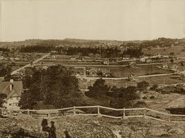
          Part two of a four-part panorama. Streets from east to west: Foul Bay Road, Irving Road, Richmond Road, Robertson Street. Streets from south to north: Lillian Road and Fairfield Road. Homes on Irving are in the 300 block, home on Foul Bay Road is 366.

          Panorama from Gonzales Hill
          AC1-M10213-M10216 · Part · [ca. 1910]
          Part of Miscellanea collection

          Part three of a four-part panorama. Background L to R: Craigdarroch Castle and water tower. Centre, L to R: 1837-1839 Fairfield Rd. (apt. bldg); intersection of Fairfield and Foul Bay Rds; Pemberton Woods; 550, 611 Foul Bay Rd. Foreground: 1901 Fairfield.