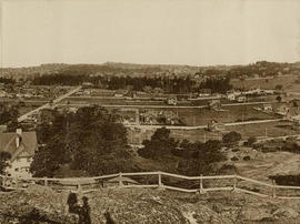
Part one of a four-part panorama. First bay on left is Gonzales (Foul) Bay, the second bay is Ross Bay and the distant point is Clover Point. Crescent Road can be seen on the left.
Part two of a four-part panorama. Streets from east to west: Foul Bay Road, Irving Road, Richmond Road, Robertson Street. Streets from south to north: Lillian Road and Fairfield Road. Homes on Irving are in the 300 block, home on Foul Bay Road is 366.
Part three of a four-part panorama. Background L to R: Craigdarroch Castle and water tower. Centre, L to R: 1837-1839 Fairfield Rd. (apt. bldg); intersection of Fairfield and Foul Bay Rds; Pemberton Woods; 550, 611 Foul Bay Rd. Foreground: 1901 Fairfield.
Part four of a four-part panorama. Background L to R: 611 Foul Bay Road; two unidentified homes; 680 Foul Bay Road. Foreground: 639 Foul Bay Road.
Showing store interior.
Housing Pemberton & Son. Looking from Broad Street.
1207 Broad Street.
N.E. corner of Broad Street and Fort Street.
South side of Yates between Blanshard Street and Quadra Street
Wharf Street in background.
On west side, between Fort and Bastion Streets.
North side, between Vancouver Street and Cook Street.
Maynard, Richard and HannahS.W. corner of Yates Street and Douglas Street