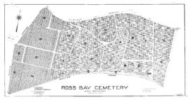
Shows buildings, railways, industrial sites and steamship lines.
Shows extent of sewer system in James Bay.
Shows park and surrounding lots.
Shows surveyed lots, railways, streetcar lines and prominent buildings. Three municipal wards in colour added by hand.
Shows depths by soundings and relief by hachures.
Shows depths by soundings and relief by contours. Inset: Continuation of Admiralty Inlet and Puget Sound.
Shows streets, roads, buildings, cultivated land, depths by soundings and relief by hachures. Includes 2 views of approaches to Esquimalt Harbour.
Includes views of Nootka Sound, Cape Alava and approaches to Juan de Fuca Strait.
Shows roads, streetcar lines, buildings, cultivated land, depths by soundings and relief by hachures. Includes 4 views. Inset: Telegraph Cove / surveyed by J.T. Walbran, Dominion Govt. S.S. "Quadra", 1900. Scale 1:3670.
Shows resurvey of Section V, Victoria District.
Contents: General plan of district. Scale [1:31 680] -- Comparative sections of dams. Scale [1:1200]. Vertical scale [1:120] -- Reduced sketch of town distribution. Scale ca. 1:23 000 -- General plan of proposed works ; Section on line of pipes. Scale [1:15 840]. Vertical scale [1:1800].
Shows location, acreage and capacity of various watersheds and locations of pipelines to Victoria.
Shows a wharf line between Songhees Point and West Bay and subdivided lots in the vicinity of Lime Bay.
Relief shown by contours. Monitor stations at Westholme, Sidney and Victoria and lines to other designated points added by hand. Inset: [Index map].
Shows surveyed lots and reserves in Victoria. Part of the title includes a panoramic view of Victoria from Songhees Point. Beckley Farm, Fairfield Estate and Finlayson and Pearse properties are noted.
John Blair's proposed plan for Beacon Hill Park. Includes index to key features: pavilion, belvedere, conservatory and flower garden, drinking fountains, park-keepers house, summer houses, bridge, water closets, fountain, zoological grounds, grotto and boiling spring.
Shows railways, bus lines and prominent buildings. Includes street index.
Shows surveyed lots and sewers.
Map covers the Hillside-Quadra District and parts of the Oaklands and Burnside Districts, but shows drains only in the Hillside-Quadra District. Fewer drains shown than in the other map of the same title (D0028).
Shows watermains in Victoria and part of present Oak Bay.
Shows drains in Victoria.
Shows drains in Victoria from Cook Street to Foul Bay Road.
Shows streets and drains in the Burnside and Victoria West Districts.
Map covers the Hillside-Quadra District and parts of the Oaklands and Burnside Districts. More drains shown than on the other maps of the same title (D0023).
Shows individual lots and corresponding street addresses.
Shows surveyed lots.
Location and size of water mains shown.
Shows individual burial plots. Some plots marked with an "O".
Shows buildings.
Shows buildings.
Shows buildings in Oak Bay, Saanich, Esquimalt and Victoria West. Each volume has an index map.
Shows buildings in Victoria West, Esquimalt, Oak Bay, Saanich and Sidney. Contents: [v.1]. Vols. 3-4 -- [v.2]. Vols. 5-6, Sidney, V.I. -- [v.3]. Street index to insurance plans of Greater Victoria.
Shows outside boundaries, plots and roadways of the cemetery.
Shows surveyed lots and prominent buildings. Insets: [Victoria and Esquimalt Land Districts]. Scale [1:63 360] -- [View of Victoria looking west from Cathedral Hill]. Annotations made by hand in red ink.
Shows surveyed lots and prominent buildings. Insets: [Victoria and Esquimalt Land Districts]. Scale [1:63 360] -- [View of Victoria looking west from Cathedral Hill].
Includes index of buildings and landmarks.
Shows surveyed lots and prominent buildings. Note in ms. (on original): "The city boundaries as defined in the "Victoria Incorporation Act, 1862" are shown in red. Mohun & Farwell, L.S., Victoria, V.I., 9th Augt. 1866."
Shows railways, streetcar and bus lines, schools, fire halls, post offices and selected holdings.
Rupert Land District. Shows pre-empted and purchased land, timber reserves and timber leases, Indian reserves and other surveyed land. Inset: Reference map.
Shows streets, railways, and prominent buildings.
Shows surveyed lots, roads, relief and land capability for agriculture. Incudes list of lots, photos and descriptions.
Shows streets, lots, railways and streetcar lines. Includes street index. Inset: Cadboro Point inset.
Shows surveyed lots and prominent buildings.
Shows railways, streetcar lines, schools, fire halls, post offices and prominent buildings. Includes street index.
Plan of lots in the vicinity of Shoal Bay (present McNeill Bay, Oak Bay, B.C.) to be sold at auction, Oct. 18, 1892, by J.P. Davies & Co. On verso: Index map, conditions of sale and catalogue of lots.
Shows extent of the sewer system in 1904.
Shows the west coast of Vancouver Island from Vargas Island to Otter Point. Surveyed land including timber leases shown.
Shows surveyed land in Sooke, Metchosin, Esquimalt, Victoria, Lake, South Saanich and North Saanich Land Districts. Inset: Town and harbour of Victoria, V.I. Scale [1:15 840].