
145 results with digital objects
Show results with digital objects

AC1-M07493
·
Item
·
[193-]
Part of Miscellanea collection

AC1-M08656
·
Item
·
[195-]
Part of Miscellanea collection

AC1-M08002
·
Item
·
[ca. 1908]
Part of Miscellanea collection

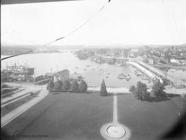
AC1-M06568
·
Item
·
[ca. 1920]
Part of Miscellanea collection
Part one of a three-part panorama. Looking north east over Rock Bay from the Victoria Gas Works.

AC1-M08754
·
Item
·
1913-1914
Part of Miscellanea collection

AC1-M06634
·
Item
·
1954
Part of Miscellanea collection
Showing the downtown area including the Empress Hotel, Inner Harbour, City Hall, and the B.C. Hydro Building under construction.
Halkett, Bill
AC1-M09121
·
Item
·
1961
Part of Miscellanea collection
AC1-M10213-M10215
·
Part
·
[ca. 1910]
Part of Miscellanea collection
Part two of a four-part panorama. Streets from east to west: Foul Bay Road, Irving Road, Richmond Road, Robertson Street. Streets from south to north: Lillian Road and Fairfield Road. Homes on Irving are in the 300 block, home on Foul Bay Road is 366.

AC1-M10218
·
Item
·
[ca. 1902]
Part of Miscellanea collection
Taken from the Parliament Buildings, showing the construction of the causeway.

AC3-LB-0506-M07548
·
Item
·
1911
Part of Library collection

AC3-LB-0540-M07196
·
Part
·
[188-]
Part of Library collection

PR-0052-M05685
·
Item
·
[197-]
Part of Alexander Roberts fonds

PR-0052-M05683
·
Item
·
1971
Part of Alexander Roberts fonds

PR-0023-M00831
·
Item
·
1910
Part of Lowe family fonds
Part two of a four-part panorama looking north-west.

PR-0023-M00832
·
Item
·
1910
Part of Lowe family fonds
Part three of a four-part panorama.

PR-0032-M00510
·
Item
·
1892
Part of Robert Taylor Williams fonds
View Street in lower left corner, Fort Street on right. Long building on upper left side is the Victoria Assembly Rooms which was turned into a roller rink December 1907.

PR-0007-M00728
·
Item
·
[ca. 1900]
Part of Arthur J. Garesche fonds
House in foreground is "Fairview" residence of Robert Dunsmuir, corner of Quebec Street and Menzies Street.
Garesche, Arthur J.
PR-0019-M05723
·
Item
Part of William Penman fonds

PR-0123-M06486
·
Item
·
[ca. 1910]
Part of Abner N. Garland collection
Showing the Parliament Buildings, the Empress Hotel, the Post Office and Custom House, and the C.P.R. Princess SS Victoria at the wharf.

PR-0124-M09695
·
Item
·
[192-?]
Part of Linn Gale fonds

PR-0252-M07175
·
Item
·
1902
Part of Ainslie James Helmcken collection

PR-0263-M00019
·
Item
·
1900
Part of Duncan D. McTavish fonds
Part one of two-part panorama taken from the Parliament Buildings.
McTavish, Duncan Douglas
PR-0263-M08362
·
Item
·
[ca. 1859]
Part of Duncan D. McTavish fonds
Looking east across harbour and Fort Victoria toward Laurel Point.

PR-0263-M09577
·
Item
·
1898
Part of Duncan D. McTavish fonds

PR-0172-M06786
·
Item
·
1948
Part of Edward R. Walker fonds

PR-0172-M06784
·
Item
·
1948
Part of Edward R. Walker fonds
Looking east.

PR-0245-M07584
·
Item
·
1916
Part of Lillian S. Smith fonds

PR-0252-M07176
·
Item
·
[ca. 1897]
Part of Ainslie James Helmcken collection

PR-0252-M06960
·
Item
·
[ca. 1912]
Part of Ainslie James Helmcken collection
Showing the Parliament Buildings. Part one of a two-part panorama.


PR-0059-M01719
·
Item
·
[ca. 1970]
Part of William E. John fonds

PR-0059-M01720
·
Item
·
[ca. 1970]
Part of William E. John fonds

PR-0059-M01722
·
Item
·
[ca. 1970]
Part of William E. John fonds

PR-0059-M02009
·
Item
·
1968
Part of William E. John fonds


AC1-M07832
·
Item
·
[189-]
Part of Miscellanea collection

AC1-M07057
·
Item
·
[192-]
Part of Miscellanea collection
Note playing field on far left. Now the site of the Crystal Gardens.

AC1-M07543
·
Item
·
[193-]
Part of Miscellanea collection
From the top of the Union Bank Building.

AC1-M07304
·
Item
·
[ca. 1900]
Part of Miscellanea collection
AC1-M07888
·
Item
·
[ca. 1900]
Part of Miscellanea collection
Richmond Road in foreground, Cedar Hill Cross Road to the right.

AC1-M07529
·
Item
·
1939
Part of Miscellanea collection

AC1-M07530
·
Item
·
1939
Part of Miscellanea collection

PR-0011-M00367
·
Item
·
[189-]
Part of George Harvey fonds

PR-0011-M08271
·
Item
·
[189-]
Part of George Harvey fonds

PR-0023-M00833
·
Item
·
1910
Part of Lowe family fonds
Part four of a four-part panorama.

PR-0026-M08894
·
Item
·
1871
Part of Dennis R. Harris fonds
Looking S.W. toward the harbour. On the south side of the street the shadows reveal Commercial and Court Alleys.
Baltzly, Benjamin, 1835-1883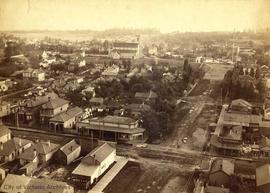
PR-0032-M00511
·
Item
·
1892
Part of Robert Taylor Williams fonds
Intersection of Blanshard and Fort Streets in foreground. Christ Church Cathedral at top centre of photo; St. Ann's Academy visible at the end of Blanshard Street.